
Page 4 - nt_tm_en
P. 4
Historical Background
Due to its strategic location at the mouth of the Pearl
River, Tuen Mun had been used as a military base and
as a centre for foreign trades since the Tang Dynasty
(610-906 AD). Tuen Mun takes its name "Tuen" from the
formation of a military base and "Mun" from the physical
setting of the area where the channel running in between
the two major mountain ranges, the Castle Peak to the
west and the Tai Lam foothills to the east, looking like a
door.
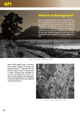
Figure 2: Rice Fields in Castle Peak in 1932
Before 1960, people living in Tuen Mun
were mostly engaged in fishing and
farming (Figure 2). Tuen Mun San Hui
was the market centre in that period.
In 1960s, Tuen Mun was identified for
new town development as part of the
Government's strategy of decentralization
of urban development from the congested
urban areas (Figure 3).
Figure 3: Tuen Mun New Town in 1963
3