
Page 15 - nt_tp_en
P. 15
Highways and Roads
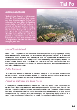
The Tolo Highway (Figure 28) , which forms part
of the New Territories Circular Road system,
runs along the southern part of the New Town
and provides high-speed links to the Main Urban
Areas and other parts of the New Territories. It
connects with the roads leading to the major
town centres in the New Territories including
Sha Tin and Tai Po to provide an efficient
road network. It is supplemented by a system
of district and local distributor roads which
penetrate all parts of the New Town. The Tolo
Highway between Island House Interchange and
Tai Hang has been widened to a dual four-lane
carriageway since 2014.
Figure 28: Tolo Highway
Internal Road Network
Within Tai Po, a comprehensive road network has been developed, with on-going upgrading of existing
roads and constraction of new roads. All cross-town and through traffic is diverted to Tai Wo Road
and Nam Wan Road to relieve the traffic at Kwong Fuk Road. The implementation of a one-way circular
traffic system along Wan Tau Street, Heung Sze Hui Street and Po Heung Street has greatly improved the
traffic congestion problems in the Tai Po Market Area. Most of the distributor roads in Tai Po have been
completed and they are linked to Tolo Highway via two major interchanges, the Island House Interchange
and the North Tai Po Interchange.
Public Transport
Tai Po New Town is served by more than 30 bus routes linking Tai Po and other parts of Kowloon and
the New Territories. Moreover, a number of public light buses and residents coaches are available for
commuters to travel between large residential estates and the MTR stations.
Pedestrian Walkways and Cycle Tracks
A comprehensive network of segregated footpaths and cycle tracks (Figure 29) has been planned for
the New Town. Major routes are through landscaped areas alongside distributor roads, the main river
channels, the waterfront and important open spaces and recreation areas. The network will not only serve
town-wide roads but also provide links into the surrounding countryside where picnic, barbecue and rest
areas are located. The cycle track which runs alongside the Tolo Highway from Sha Tin to Tai Mei Tuk is
one of the most popular routes in the territory particularly during weekends and public holidays.
14