
Page 88 - ar2018_en
P. 88
Conservation-Related Zones
The scarcity of land resulting in increasing development pressure pose threats to our natural
environment. Through zoning designation, we help safeguard our natural environment
against undesirable development in areas of high conservation value. As at end of 2017,
about 11 948.16 hectares of land in the territory (or 19.62 per cent of land within statutory
plans) fall within the following conservation-related zones on the relevant statutory plans:
‘Conservation Area’, ‘Site of Special Scientific Interest’, ‘Country Park’, ‘Coastal Protection
Area’, and ‘Other Specified Uses’ annotated ‘Comprehensive Development to include
Wetland Restoration Area’; ‘Comprehensive Development and Wetland Enhancement Area’;
and ‘Comprehensive Development and Wetland Protection Area’.
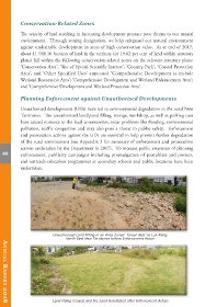
Planning Enforcement against Unauthorised Developments
Unauthorised developments (UDs) have led to environmental degradation in the rural New
Territories. The unauthorised land/pond filling, storage, workshop, as well as parking uses
have caused nuisance to the local communities, incur problems like flooding, environmental
pollution, traffic congestion and may also pose a threat to public safety. Enforcement
and prosecution actions against the UDs are essential to help prevent further degradation
of the rural environment (see Appendix 3 for summary of enforcement and prosecution
actions undertaken by the Department in 2017). To increase public awareness of planning
85 enforcement, publicity campaigns including promulgation of pamphlets and posters,
and outreach education programmes at secondary schools and public locations have been
undertaken.
Unauthorised Land Filling in an Area Zoned ‘Green Belt’ at Luk Keng,
North East New Territories before Enforcement Action
Land Filling Ceased and the Land Reinstated after Enforcement Action
AnnuAl RepoRt 2018