
Page 52 - ar2018_en
P. 52
revIew StuDy oF KaI taK Development
Planning History
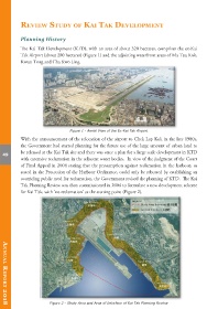
The Kai Tak Development (KTD), with an area of about 320 hectares, comprises the ex-Kai
Tak Airport (about 280 hectares) (Figure 1) and the adjoining waterfront areas of Ma Tau Kok,
Kwun Tong and Cha Kwo Ling.
Figure 1 - Aerial View of the Ex-Kai Tak Airport
With the announcement of the relocation of the airport to Chek Lap Kok in the late 1980s,
the Government had started planning for the future use of the large amount of urban land to
be released at the Kai Tak site and there was once a plan for a large scale development in KTD
49
with extensive reclamation in the adjacent water bodies. In view of the judgment of the Court
of Final Appeal in 2004 stating that the presumption against reclamation in the harbour, as
stated in the Protection of the Harbour Ordinance, could only be rebutted by establishing an
overriding public need for reclamation, the Government revised the planning of KTD. The Kai
Tak Planning Review was then commissioned in 2004 to formulate a new development scheme
for Kai Tak, with ‘no reclamation’ as the starting point (Figure 2).
Figure 2 - Study Area and Area of Interface of Kai Tak Planning Review
AnnuAl RepoRt 2018