
Page 22 - ar2019_en
P. 22
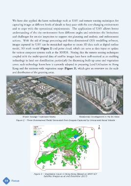
We have also applied the latest technology such as UAV and remote sensing techniques for
            capturing images at different levels of details to keep pace with the ever-changing environment
            and to cope with the operational requirements.  The application of UAV allows better
            understanding of the site environment from different angles and minimises the limitations

            and challenges for on-site inspection to support site planning and analysis, and enforcement
            actions.  With the aid of image processing and three-dimensional (3D) modelling software,
            images captured by UAV can be mosaicked together to create 3D data such as digital surface
            model, 3D mesh model (Figure 2) and point cloud, which can serve as data input or update

            for various computer systems such as the 3DPDS.  Noting that the remote sensing techniques
            coupled with the multi-spectral data of satellite images have been well-received as an enabling
            technology in land use classification particularly for discerning built-up areas and vegetation
            cover, such technology know-how is currently adopted in preparing Land Utilisation in Hong

            Kong and the territory-wide vegetation maps (Figure 3), which give an overview on the scale
            and distribution of the greening areas.


                      Shatin Sewage Treatment Works                      Residential Development in Ma On Shan
                Figure 2 - Three-Dimensional Model Generated from Images Captured by Unmanned Aerial Vehicle


                                Figure 3 – Vegetation Cover in Hong Kong (Based on SPOT 6/7
                                         Satellite Images as at end December 2017)
     19     Focus