
Page 25 - ar2019_en
P. 25
Focus
Visualisation of Information in 3D Environment
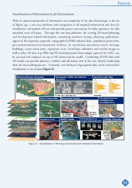
With an exponential growth of information and complexity of the data format/type in the era
of digital age, a one-stop platform with integration of all required information and data for
visualisation and analysis will not only provide greater convenience for daily operation, but also
maximise work efficiency. Through this one-stop platform, the existing 2D based planning
and development-related information, comprising statutory zonings, planning applications,
approved development proposals, topographic/LiDAR/cadastral data, population projections,
government/institution/community facilities, air ventilation assessment results, heritage
buildings, conservation areas, vegetation cover, broad land utilisation and satellite images as
well as other 3D data (e.g. BIM and 3D model generated from images captured by UAV), can
be accessed and displayed on top of 3D photo-realistic model. Combining 2D/3D data with
3D model can provide planners a holistic and all-seeing view of the city, thereby facilitating
their decision-making process. Currently, over 60 layers of geospatial data can be retrieved for
visualisation in the system (Figure 9).
Figure 9 – Visualisation of Planning and Development-Related Information
22