
Page 21 - ar2019_en
P. 21
Focus
sum, the over-arching policy direction provides impetus for action to reap the benefits of
innovation and technology as well as smart initiatives to enhance planning work, and hence
move towards smart city development.
Application of Information and Technology in Town Planning
Since the establishment of the Department in 1990, it has endeavored to explore various
initiatives to leverage the latest innovation and enabling technology in facilitating the daily
planning work, including site search, plan making, development assessment, enforcement
actions against unauthorised development, planning information dissemination and public
engagement.
Starting from early nineteen-nineties, various Geographic Information Systems (GIS) have
been developed to support the Town Planning Board (TPB) in the preparation of statutory
outline zoning plans (OZPs) and monitoring the processing of planning applications. To
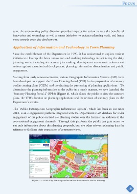
disseminate the planning information to the public in a timely manner, we have launched the
‘Statutory Planning Portal 2’ (SPP2) (Figure 1), which allows the public to view the statutory
plans, the TPB's decision on planning applications and the revision of statutory plans via the
Department’s website.
The ‘Public Participation Geographic Information System’, which has been in use since
2012, is an e-engagement platform integrated with the Department’s GIS database for wider
engagement of the public on land use planning studies over the Internet, in addition to the
conventional engagement channels. Through this platform, the public can gain access to
not only information about the planning proposals, but also other relevant planning data for
reference to facilitate their preparation of comments/views.
Figure 1 – Statutory Planning Information Available for Public Viewing
18