
Page 23 - ar2019_en
P. 23
Focus
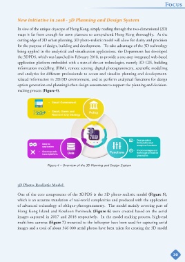
New initiative in 2018 - 3D Planning and Design System
In view of the unique cityscape of Hong Kong, simply reading through the two-dimensional (2D)
maps is far from enough for town planners to comprehend Hong Kong thoroughly. At the
cutting edge of 3D urban planning, 3D photo-realistic model will allow for clarity and precision
for the purpose of design, building and development. To take advantage of the 3D technology
being applied in the analytical and visualization applications, the Department has developed
the 3DPDS, which was launched in February 2018, to provide a one-stop integrated web-based
application platform embedded with a state-of-the-art technologies, namely 3D GIS, building
information modelling (BIM), remote sensing, digital photogrammetry, scientific modelling
and analytics for different professionals to access and visualise planning and development-
related information in 2D/3D environment, and to perform analytical functions for design
option generation and planning/urban design assessments to support the planning and decision-
making process (Figure 4).
Figure 4 – Overview of the 3D Planning and Design System
3D Photo-Realistic Model
One of the core components of the 3DPDS is the 3D photo-realistic model (Figure 5),
which is an accurate translation of real-world complexities and produced with the application
of advanced technology of oblique-photogrammetry. The model mainly covering part of
Hong Kong Island and Kowloon Peninsula (Figure 6) were created based on the aerial
images captured in 2017 and 2018 respectively. In the model making process, high-end
multi-lens cameras (Figure 7) mounted to the helicopter have been used for capturing aerial
images and a total of about 346 000 aerial photos have been taken for creating the 3D model
20